The world's ocean is vast and open, but global trade is not. Roughly 80,000 commercial vessels are at sea on any given day, and a staggering share of them must thread the same handful of narrow passages. Five waterways, none wider than a few dozen kilometers, collectively handle somewhere between 40% and 60% of all seaborne trade, depending on how you measure it. They are the arteries of the global economy. When they constrict, everything downstream -- freight rates, commodity prices, insurance premiums, and eventually the cost of groceries and gasoline -- responds.
These passages are called chokepoints, and the term is precise. A chokepoint is any place where geography forces shipping traffic to converge into a narrow corridor with no practical alternative. Rerouting around a closed chokepoint can add thousands of nautical miles and weeks of transit time to a voyage. In some cases, there is no alternative at all.
This module covers the five chokepoints that matter most to the global economy in 2026: the Suez Canal, the Panama Canal, the Strait of Hormuz, the Strait of Malacca, and the Bab-el-Mandeb. Each shapes trade flows in a different way, carries different commodities, and faces different risks. Together they form the structural map of global commerce -- the places where geography, politics, climate, and economics collide.
1. The Suez Canal

The Suez Canal is the single most important artificial waterway on Earth. Cut through 193 kilometers of Egyptian desert between 1859 and 1869, it eliminates the need for ships traveling between Europe and Asia to circumnavigate Africa -- a detour that adds roughly 6,000 nautical miles and two weeks to a voyage. In 2023, before the Houthi disruption began, the canal handled about 23,000 transits carrying goods worth over $1 trillion. The Suez Canal Authority reported revenues of $9.4 billion that year, a record.
The canal has no locks. Ships transit at sea level, which makes passage relatively fast -- about 12 to 16 hours from end to end. A 2015 expansion added a 35-kilometer parallel channel, allowing two-way traffic along part of the route and increasing daily capacity to roughly 97 vessels, though actual daily transits typically average 50 to 60.
The Ever Given: Six Days That Proved the Point
On March 23, 2021, the 400-meter container ship Ever Given ran aground in the canal's southern section, wedging itself diagonally across the entire waterway. For six days, nothing moved. The blockage trapped 422 vessels in queue, delayed an estimated $9.6 billion in trade per day, and forced dozens of ships to reroute around the Cape of Good Hope. Container spot rates on the Asia-Europe trade lane jumped 47% within a week.
The incident was brief enough that its consumer price impact remained modest -- roughly 0.2 to 0.4 percentage points on shipping-sensitive goods over the following two months, according to subsequent analysis by the International Monetary Fund. But it demonstrated, vividly and publicly, how fragile the system is. One ship, one canal, one bad day.
2024: The Houthi Crisis Changes Everything
The Ever Given was an accident. What began in November 2023 was something far more consequential: deliberate, sustained military disruption. Yemen's Houthi forces, responding to the Israel-Hamas conflict, started attacking commercial vessels transiting the southern approaches to the Suez Canal. By January 2024, the majority of container lines had rerouted their Asia-Europe services around the Cape of Good Hope, adding 10 to 14 days to transit times and sharply increasing fuel costs. Suez Canal transits fell by more than 50% compared with the prior year. Asia-to-Europe container rates tripled between December 2023 and January 2024 on the Shanghai Containerized Freight Index.
The effects are still being felt. As of early 2026, many carriers continue to avoid the Red Sea route entirely. The Suez Canal Authority has lost billions in toll revenue. Insurance premiums for Red Sea transits remain elevated by 300% to 500% above pre-crisis levels. And the cost of rerouting -- in fuel, time, and vessel availability -- has become embedded in freight rate baselines, contributing to a structural shift in container shipping costs that feeds into consumer prices with a 30-to-90-day lag.
2. The Panama Canal
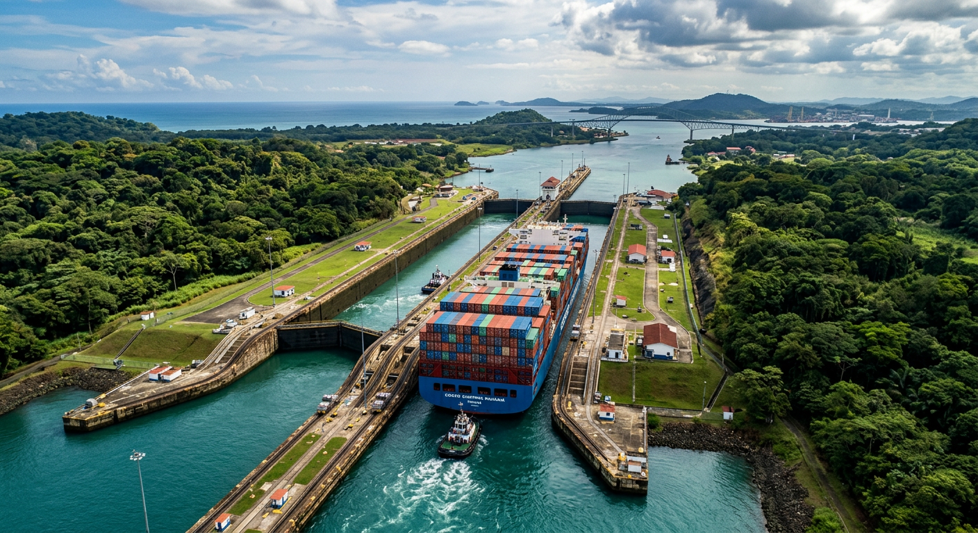
The Panama Canal is the only waterway connecting the Atlantic and Pacific oceans without rounding South America -- a passage around Cape Horn that adds 8,000 nautical miles and three weeks to most voyages. Completed in 1914 after a decade of construction that killed more than 5,000 workers, the canal uses a lock system to raise ships 26 meters (85 feet) above sea level to Gatun Lake, then lower them back down on the other side. The system depends entirely on freshwater from rainfall. That fact, unremarkable for a century, has become the canal's defining vulnerability.
The canal matters disproportionately to American trade. About 40% of all U.S. container traffic passes through it, including a large share of consumer goods from East Asia bound for the Gulf Coast and East Coast ports. It is also the primary route for U.S. LNG exports to Asian markets -- a trade flow that has grown rapidly since 2016 and now accounts for billions of dollars in annual commerce. The Panama Canal Authority reported total cargo volume of 518 million tons in fiscal year 2023, before drought restrictions forced cutbacks.
The 2023-24 Drought: When Rain Becomes a Commodity
Gatun Lake, the artificial reservoir that supplies water for every lock cycle, requires consistent tropical rainfall to maintain its operating level. Each transit consumes roughly 200 million liters of fresh water. In the second half of 2023, an El Nino-driven drought dropped Gatun Lake to its lowest level in recorded history. The Canal Authority responded by cutting daily transits from a normal 36-38 down to 24, and then to 22 by February 2024.
The restrictions created a bottleneck with immediate financial consequences. Wait times for unreserved transits stretched to 21 days. Auction prices for priority booking slots -- normally around $50,000 to $100,000 -- surged past $4 million in November 2023. Dry bulk carriers and LNG tankers were hit hardest. U.S. LNG exports to Asia were rerouted through Suez (adding cost and time) or around Cape Horn (adding far more of both). Grain shipments from the Gulf of Mexico to Asia faced similar detours.
The drought restrictions eased through mid-2024 as rainfall returned, but the episode exposed a structural risk that climate models suggest will recur with increasing frequency. The canal's dependence on seasonal rainfall, in a region where precipitation patterns are shifting, means that the Panama Canal's capacity is no longer a fixed quantity. It is a variable, influenced by global climate dynamics that are trending in the wrong direction.
3. The Strait of Hormuz
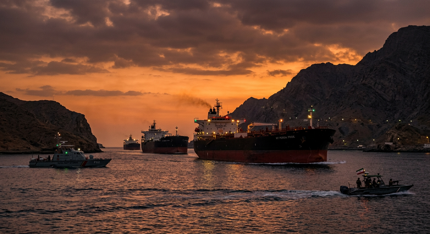
If the Suez Canal is the world's most important artificial waterway, the Strait of Hormuz is the most important natural one. This narrow passage between Iran to the north and Oman and the United Arab Emirates to the south is just 33 kilometers wide at its narrowest. The navigable shipping channels are far tighter -- two lanes, each about 3 kilometers wide, separated by a 3-kilometer buffer zone. Through this corridor flows roughly 20% to 25% of the world's oil supply and about 25% of global LNG.
The numbers are worth pausing on. The U.S. Energy Information Administration estimates that roughly 21 million barrels of oil per day transited Hormuz in 2023. Saudi Arabia, Iraq, Kuwait, the UAE, and Qatar all depend on the strait for the majority of their hydrocarbon exports. There is no alternative. Saudi Arabia has a limited-capacity pipeline to the Red Sea (the East-West Pipeline, about 5 million barrels per day capacity), and the UAE has a pipeline to Fujairah on the Gulf of Oman. But combined, these bypass routes can handle less than a third of normal Hormuz throughput. Everything else must go through the strait.
Iran's Leverage
Iran's coastline runs along the entire northern shore of the strait. Its military installations, naval bases, and missile batteries sit within easy range of every vessel in transit. Iran has never fully closed the strait -- doing so would also block its own oil exports -- but it has repeatedly demonstrated the ability to harass, threaten, and selectively interdict shipping. Seizures of tankers, drone deployments, mine-laying exercises, and fast-boat confrontations with naval escorts have occurred regularly since the 1980s.
The 2026 Iran crisis elevated these risks to a level not seen since the Tanker War of 1984-88. Tensions between Iran and Western nations over nuclear program developments produced a series of confrontations in and around the strait. War-risk insurance premiums for vessels transiting Hormuz spiked to levels that added $500,000 or more to a single VLCC (Very Large Crude Carrier) transit. Brent crude prices jumped 15% in three weeks. The impact on gasoline prices reached U.S. consumers within 10 to 14 days, a transmission speed considerably faster than for containerized goods, because oil markets are traded in real time and refiners adjust rack prices immediately when crude input costs rise.
Why Hormuz Hits Your Wallet Fastest
Of all five chokepoints, Hormuz has the most direct and rapid connection to consumer prices in the United States. The mechanism is straightforward: crude oil prices respond within hours to Hormuz tensions. Refinery input costs adjust within days. Wholesale gasoline prices follow within a week. Retail pump prices follow within two weeks. Unlike container freight, which takes 30 to 120 days to reach the checkout counter, Hormuz disruptions hit household budgets almost immediately through fuel costs -- and fuel costs feed into the price of transporting everything else.
4. The Strait of Malacca
The Strait of Malacca is the busiest chokepoint in the world by vessel count. Stretching 900 kilometers between the Malay Peninsula and the Indonesian island of Sumatra, it funnels traffic between the Indian Ocean and the South China Sea -- and by extension, between the Middle East, Europe, and Africa on one side and East Asia on the other. More than 80,000 vessels per year transit the strait, carrying roughly a quarter of all goods moved by sea.
The strait narrows dramatically at its southeastern end, where the Phillips Channel near Singapore is just 2.8 kilometers wide and, in places, only 25 meters deep. That depth limit excludes the largest class of supertankers (ULCCs) when fully loaded, forcing some to take the longer route through the Lombok or Makassar Straits in Indonesia. For everything else -- container ships, VLCCs at partial draft, bulk carriers, LNG tankers -- Malacca is the only practical route.
China's Oil Lifeline
No country depends on Malacca more than China. Roughly 80% of China's oil imports and a large share of its LNG imports transit the strait. This dependency -- which Chinese strategic planners call the "Malacca Dilemma" -- is a defining concern of Chinese foreign policy and military planning. It explains, in part, China's massive investment in overland pipelines (the China-Myanmar crude oil pipeline, operational since 2017, can carry 440,000 barrels per day), its development of port facilities in Pakistan (Gwadar) and Sri Lanka (Hambantota), and its expanding naval presence in the South China Sea and Indian Ocean.
Despite these alternatives, the math is stark. China imports roughly 11 million barrels of oil per day. Overland and bypass routes can handle perhaps 1.5 to 2 million barrels per day at maximum capacity. Malacca remains irreplaceable for the foreseeable future. A sustained closure -- whether from military conflict, a catastrophic grounding, or coordinated piracy -- would be an existential economic event for the world's second-largest economy.
Piracy and Congestion
The strait has a long history of piracy, though internationally coordinated naval patrols by Malaysia, Singapore, and Indonesia (the Malacca Strait Patrol) have reduced incidents sharply since the mid-2000s. The ICC International Maritime Bureau reported fewer than 10 piracy and armed robbery incidents in the strait in 2023, down from over 150 in 2000. The greater operational risk today is congestion: with vessel traffic growing steadily and the physical dimensions of the strait fixed, the margin for navigational error shrinks every year. A major grounding at the Phillips Channel -- an Ever Given-type event in a natural waterway -- would be catastrophically difficult to clear.
5. Bab-el-Mandeb
The name means "Gate of Tears" in Arabic, and it has earned the title. The Bab-el-Mandeb strait, separating Yemen from Djibouti and Eritrea at the southern mouth of the Red Sea, is the mandatory passage for any vessel heading to or from the Suez Canal. The two chokepoints function as a single system: closing Bab-el-Mandeb is functionally equivalent to closing the Suez Canal, because no ship can reach Suez from the south without passing through it first.
At 26 kilometers wide, Bab-el-Mandeb appears less constrained than some other chokepoints. But the small island of Perim (controlled by Yemen) sits in the middle of the strait, splitting traffic into two channels. The western channel, between Perim and Djibouti, is about 16 kilometers wide. The eastern channel, between Perim and the Yemeni coast, is narrower and shallower. Most commercial traffic uses the western channel, which provides deeper water and a more direct approach to the Red Sea.
The Houthi Campaign
Since November 2023, the Bab-el-Mandeb has been the epicenter of the most significant disruption to global shipping since the COVID pandemic. Houthi forces in Yemen, using anti-ship ballistic missiles, cruise missiles, armed drones, and fast attack boats, have attacked commercial vessels in and around the strait. The attacks are nominally in solidarity with Palestinians in Gaza, but they have struck ships with no connection to Israel, including vessels flagged to nations with no involvement in the conflict.
The shipping industry's response was swift and dramatic. By December 2023, Maersk, MSC, Hapag-Lloyd, CMA CGM, and most other major container lines had suspended Red Sea transits and rerouted around Africa. The diversions added 3,000 to 3,500 nautical miles to Asia-Europe routes, increasing transit times by 10 to 14 days and fuel consumption by 30% to 40% per voyage. On the Shanghai Containerized Freight Index, the composite rate more than doubled between late November 2023 and mid-January 2024.
U.S. and coalition naval forces launched Operation Prosperity Guardian and subsequently conducted strikes against Houthi military targets. But the attacks on shipping continued through 2024 and into 2025. The Houthis demonstrated a capacity for sustained asymmetric warfare that conventional naval power could deter but not eliminate. As of early 2026, the strait remains a conflict zone, and the majority of container traffic continues to avoid it. The effects on the Suez Canal's throughput, and on global container rates, have been persistent rather than transitory.
Bab-el-Mandeb and the Suez: A Linked System
One fact that is underappreciated in most media coverage: Bab-el-Mandeb and the Suez Canal are not independent chokepoints. They form a single corridor. A vessel traveling from Shanghai to Rotterdam via Suez must pass through both. Disruption at either end blocks the entire route. The Houthi attacks target the southern entrance, but the consequence is identical to blocking the canal itself -- ships reroute around Africa, and the cost of that reroute is borne by shippers, freight forwarders, and ultimately consumers.
This linked-system concept is central to how Risk and Route calculates its Route Disruption Index. A severity spike at Bab-el-Mandeb automatically increases the Suez Canal's effective disruption score, because the operational impact is inseparable.
How the Five Chokepoints Connect
These five waterways do not operate in isolation. A disruption at one frequently cascades to others by absorbing the vessels, port capacity, and schedule slack that other routes depend on.
When the Houthi attacks forced diversions away from Suez and Bab-el-Mandeb, vessel demand on the Cape of Good Hope route surged, pulling ships out of other trades. Container lines redeployed vessels from intra-Asia and trans-Pacific routes to cover the longer Asia-Europe voyages, tightening capacity across the entire global network. At the same time, the Panama Canal was restricting transits due to drought. Shippers who might have rerouted trans-Pacific cargo through Panama found that option constrained as well. The result was a simultaneous capacity squeeze at two of the five major chokepoints -- something that had not occurred before at this scale.
The Hormuz dimension compounds the picture. The oil that flows through Hormuz supplies refineries in Asia, and much of it reaches those refineries via the Strait of Malacca. An escalation at Hormuz tightens global oil supply, raises crude prices, and increases the cost of bunker fuel -- the heavy fuel oil that powers most cargo ships. Higher bunker costs, in turn, make the longer rerouting distances forced by Suez/Bab-el-Mandeb disruptions even more expensive. The feedback loops are real and measurable.
This interconnection is why monitoring any single chokepoint in isolation gives an incomplete picture. The global shipping network is a system, and the five chokepoints are its critical nodes. Stress on any one of them propagates through the network in ways that are predictable in direction but difficult to quantify in magnitude.
Key Takeaways
- 1. Five chokepoints -- Suez, Panama, Hormuz, Malacca, and Bab-el-Mandeb -- collectively handle 40-60% of global seaborne trade. Their narrowness makes them structurally vulnerable to disruption from military conflict, weather, mechanical accidents, and climate change.
- 2. Different chokepoints carry different commodities and affect prices through different channels. Hormuz disruptions hit fuel prices within days. Suez disruptions hit containerized goods over weeks to months. Panama disruptions affect U.S.-specific trade flows and LNG exports.
- 3. Bab-el-Mandeb and the Suez Canal function as a single linked corridor. Disruption at either end blocks the entire route between Asia and Europe via the Red Sea.
- 4. Chokepoint disruptions cascade. When one passage closes, vessels reroute, absorbing capacity and schedule slack on alternative routes. Simultaneous disruptions at multiple chokepoints -- as occurred in late 2023 and early 2024 -- produce compounding effects across the entire global shipping network.
- 5. There is no substitute for these waterways. Pipelines, overland routes, and alternative straits exist but can handle only a fraction of normal chokepoint throughput. The geography of global trade is fixed. The risks are structural.